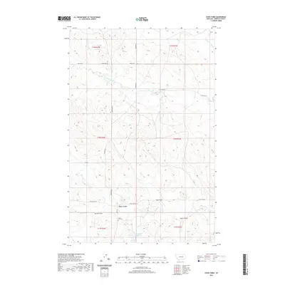
2020 Map of Steve Forks
USGS Topo · Published 2020About this map
Steve Forks serves as a primary geographic anchor in this Garfield County landscape, characterized by the drainage patterns of Lone Tree Cr and its various branches. The area is defined by a series of geographic depressions known locally as coulees, including Meckel Coulee, King Coulee, and Baker Coulee, which shape the local hydrology and movement across the terrain. A sparse network of county roads like Edwards Rd and Steve's Fork Rd connects these points of interest, facilitating transit through a region where water management is visible at the Wheatcroft Reservoir. For those researching local family history or land use, the Steve Forks Cem provides a significant genealogical reference point, situated near the intersection of several sections. The map reveals the relationship between early ranching routes and the natural watercourses like Cherry Cr and Camp Cr that dictate the settlement's footprint.
Find a feature on this map
27 named features on this map. Tap any name to fly to it.
Don’t see what you’re looking for? This feature index may not catch every label — zoom into the map to look around manually.
Map Details
Editions of this 2020 Steve Forks Map
This is the sole edition of this map. No revisions or reprints were ever made.
Other maps of this area

1954 · Jordan
USGS Topo · 1:250,000

1956 · Jordan
USGS Topo · 1:250,000

1958 · Jordan
USGS Topo · 1:250,000

1964 · Jordan
USGS Topo · 1:250,000

1965 · Big Dry School
USGS Topo · 1:24,000

1965 · Edwards
USGS Topo · 1:24,000
1965 · Twin Buttes
USGS Topo · 1:24,000

1983 · Steve Forks
USGS Topo · 1:24,000
1983 · Blackfoot School
USGS Topo · 1:24,000
1983 · Brusett
USGS Topo · 1:24,000