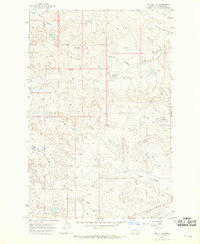
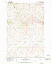
1965 Map of Twin Buttes
USGS Topo · Published 1969About this map
Twin Buttes rises as the primary landmark in this remote section of Garfield County, where the topography is defined by the winding drainages of Middle Fork Lodgepole Creek and Haislett Creek. The 1960s landscape shows a sparse pattern of high plains ranching and rural infrastructure, anchored by the Meckel Sch and the small settlement at Cairo. Numerous coulees, such as Bobcat Coulee, Meckel Coulee, and Dugout Coulee, carve through the terrain, illustrating the complex drainage patterns of the eastern Montana breaks. Fine red dashed lines throughout the map delineate selected fence lines, providing a rare look at property boundaries and land use in this open range country during the mid-century era.
Find a feature on this map
10 named features on this map. Tap any name to fly to it.
Don’t see what you’re looking for? This feature index may not catch every label — zoom into the map to look around manually.
Map Details
Editions of this 1965 Twin Buttes Map
This is the sole edition of this map. No revisions or reprints were ever made.
Other maps of this area

1954 · Jordan
USGS Topo · 1:250,000

1956 · Jordan
USGS Topo · 1:250,000

1958 · Jordan
USGS Topo · 1:250,000

1964 · Jordan
USGS Topo · 1:250,000

1965 · Robertson School
USGS Topo · 1:24,000

1965 · Edwards
USGS Topo · 1:24,000
1965 · Sand Springs
USGS Topo · 1:24,000
1967 · Cox Butte
USGS Topo · 1:24,000
1967 · Coffin Butte
USGS Topo · 1:24,000
1967 · Hay Coulee
USGS Topo · 1:24,000