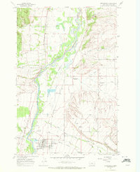
1967 Map of Stevensville
USGS Topo · Published 1972About this map
Stevensville and the surrounding valley floor appear here during the late 1960s, defined by the broad curves of the Bitterroot River and a complex network of water management features. The town’s history is anchored by the Fort Owen (Historical Site) and the St Marys Cem, reflecting its status as one of Montana's oldest colonial settlements. West of the river, the Bitterroot National Forest rises sharply toward the Bitterroot Range, while the valley center is dedicated to the Ravalli National Wildlife Refuge. The landscape is a study in transport and utility, showing the Burlington Northern line and the Lewis and Clark Trail passing through Kenspur, alongside the Bitterroot Irrigation Dist Canal and the Supply Ditch which facilitated the region's agricultural productivity.
Find a feature on this map
36 named features on this map. Tap any name to fly to it.
Don’t see what you’re looking for? This feature index may not catch every label — zoom into the map to look around manually.
Map Details
Editions of this 1967 Stevensville Map
2 editions found
Other maps of this area

1901 · Hamilton
USGS Topo · 1:125,000

1903 · Bonner
USGS Topo · 1:125,000

1909 · Sapphire
USGS Topo · 1:125,000

1912 · Missoula
USGS Topo · 1:125,000

1947 · Butte
USGS Topo · 1:250,000

1956 · Hamilton
USGS Topo · 1:250,000

1958 · Butte
USGS Topo · 1:250,000

1959 · Hamilton
USGS Topo · 1:250,000

1959 · Cleveland Mountain
USGS Topo · 1:62,500

1960 · Butte
USGS Topo · 1:250,000