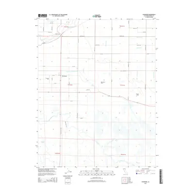
2015 Map of Stevinson
USGS Topo · Published 2015About this map
The San Joaquin Valley landscape around Stevinson is defined by an intricate network of water management and river systems as they appeared in 2015. The Merced River flows through the northern reaches, crossed by the Milliken Bridge, while the San Joaquin River meanders through the southern half of the quadrangle. This area represents a critical intersection of natural hydrology and agricultural engineering, evidenced by a dense grid of laterals and canals such as the East Side Irrigation Canal, McCoy Lateral, and Adams Ditch.
Find a feature on this map
56 named features on this map. Tap any name to fly to it.
Don’t see what you’re looking for? This feature index may not catch every label — zoom into the map to look around manually.
Map Details
Editions of this 2015 Stevinson Map
This is the sole edition of this map. No revisions or reprints were ever made.
Other maps of this area

1916 · Mitchell School
USGS Topo · 1:31,680

1916 · Cressey
USGS Topo · 1:31,680

1917 · Turlock
USGS Topo · 1:31,680

1918 · Arena
USGS Topo · 1:31,680

1918 · Stevinson
USGS Topo · 1:31,680

1918 · Gustine
USGS Topo · 1:31,680

1918 · Turner Ranch
USGS Topo · 1:31,680

1919 · San Luis Ranch
USGS Topo · 1:31,680

1919 · Ingomar
USGS Topo · 1:31,680
1942 · Irwin
USGS Topo · 1:62,500