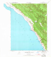
1943 Map of Stewarts Point
USGS Topo · Published 1968About this map
Stewarts Point and the dramatic Sonoma coastline are mapped here during the early 1940s by the Geological Survey and the Corps of Engineers. This coastal landscape is defined by its maritime connections, from the sheltered waters of Fisherman Bay and Black Pt Landing to the northern edge of Del Mar Landing. The interior reveals a complex drainage system where the Wheatfield Fork Gualala River meets the South Fork Gualala River near Valley Crossing. High ground is dominated by the long stretch of German Ridge and Stanley Ridge, which flank the deep incisions of Buckeye Creek and Brush Creek. The map documents a period when these small coastal outposts relied on the narrow littoral shelf and river valleys for movement before modern infrastructure fully reshaped the region.
Find a feature on this map
20 named features on this map. Tap any name to fly to it.
Don’t see what you’re looking for? This feature index may not catch every label — zoom into the map to look around manually.
Map Details
Editions of this 1943 Stewarts Point Map
3 editions found
Other maps of this area

1921 · Plantation
USGS Topo · 1:62,500

1943 · Point Arena
USGS Topo · 1:62,500

1943 · Stewarts Point
USGS Topo · 1:24,000

1943 · Plantation
USGS Topo · 1:24,000

1943 · Annapolis
USGS Topo · 1:24,000

1943 · Ornbaun
USGS Topo · 1:62,500

1944 · Annapolis
USGS Topo · 1:31,680
1944 · Plantation
USGS Topo · 1:31,680

1944 · Stewarts Point
USGS Topo · 1:31,680

1944 · Ornbaun
USGS Topo · 1:62,500