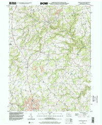
1999 Map of Stewartstown
USGS Topo · Published 2002About this map
The rolling agricultural landscape of York County is punctuated by a string of historic milling sites along the intricate creek systems that define this region. Sechrist Mill sits at the northern end of the map, while Hyson Mill, Cross Mill, and Bacon Mill follow the waterways through East Hopewell toward the southern reaches of Stewartstown. This distribution of water-powered industry suggests a long-standing rural economy centered on local grain processing and community hubs.
Find a feature on this map
52 named features on this map. Tap any name to fly to it.
Don’t see what you’re looking for? This feature index may not catch every label — zoom into the map to look around manually.
Map Details
Editions of this 1999 Stewartstown Map
This is the sole edition of this map. No revisions or reprints were ever made.
Other maps of this area

1900 · Parkton
USGS Topo · 1:62,500

1901 · Belair
USGS Topo · 1:62,500

1902 · Parkton
USGS Topo · 1:62,500

1908 · York
USGS Topo · 1:62,500

1910 · York
USGS Topo · 1:62,500

1912 · Mc Calls Ferry
USGS Topo · 1:62,500

1942 · Bel Air
USGS Topo · 1:62,500

1943 · Mc Calls Ferry
USGS Topo · 1:62,500

1944 · New Freedom
USGS Topo · 1:31,680

1944 · Norrisville
USGS Topo · 1:31,680