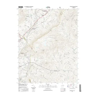
2016 Map of Stewartsville
USGS Topo · Published 2016About this map
Coyner Mtn and the winding path of the Blue Ridge Parkway define this portion of the Virginia highlands where Roanoke, Botetourt, and Bedford counties meet. The landscape is a network of ridges and knobs, including Stewart Knob and Horsepen Mtn, which separate the various drainages of Glade Cr and Falling Cr. The settlement pattern follows the lower elevations, with Stewartsville and Laymantown serving as primary local hubs. The area is dotted with numerous family and community burial grounds such as Lawhorn Cem and Giles Cem, indicating deep-rooted genealogical history in the rural spaces between the larger summits. Toward the southwest, the Roanoke River passes by Niagara, where the Niagara Reservoir sits near the edge of Vinton. The map also captures significant water management features like Beaverdam Reservoir and Falling Cr Reservoir, highlighting how the natural topography has been utilized for regional resources.
Find a feature on this map
50 named features on this map. Tap any name to fly to it.
Don’t see what you’re looking for? This feature index may not catch every label — zoom into the map to look around manually.
Map Details
Editions of this 2016 Stewartsville Map
This is the sole edition of this map. No revisions or reprints were ever made.
Other maps of this area

1890 · Roanoke
USGS Topo · 1:125,000

1891 · Roanoke
USGS Topo · 1:125,000

1929 · Roanoke
USGS Topo · 1:48,000

1933 · Roanoke
USGS Topo · 1:62,500

1947 · Roanoke
USGS Topo · 1:250,000

1950 · Peaks of Otter
USGS Topo · 1:62,500

1951 · Boones Mill
USGS Topo · 1:62,500

1951 · Moneta
USGS Topo · 1:62,500

1959 · Roanoke
USGS Topo · 1:250,000
1962 · Roanoke
USGS Topo · 1:24,000