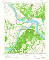
1964 Map of Stigler NE
USGS Topo · Published 1964About this map
The Arkansas River and Canadian River converge here, creating a complex landscape of fertile lowlands and shifting river boundaries. In the early 1960s, these alluvial plains are identified as Campbell Bottom, Sadie Bottom, and Sandtown Bottom, areas historically vital for agriculture and river-based transport. The Missouri Pacific railroad cuts through the northern section near Upson Siding, while the surrounding hills are marked by a high density of family and community burial sites, including the Fields Cem, Jones Cem, and Hefley Cem. Educational and spiritual life centers on landmarks like the Stony Point Sch, McIntosh Chapel, and Rock Hill Ch. The mapping of an Indefinite Boundary along the river channels reflects the dynamic nature of this water-dominated geography at the intersection of Sequoyah, Muskogee, and Haskell counties.
Find a feature on this map
49 named features on this map. Tap any name to fly to it.
Don’t see what you’re looking for? This feature index may not catch every label — zoom into the map to look around manually.
Map Details
Editions of this 1964 Stigler NE Map
This is the sole edition of this map. No revisions or reprints were ever made.
Other maps of this area

1898 · Tahlequah
USGS Topo · 1:125,000

1900 · Sansbois
USGS Topo · 1:125,000

1900 · Sallisaw
USGS Topo · 1:125,000

1901 · Muscogee
USGS Topo · 1:125,000

1901 · Tahlequah
USGS Topo · 1:125,000

1905 · Muscogee
USGS Topo · 1:125,000

1905 · Tahlequah
USGS Topo · 1:125,000

1909 · Sans Bois
USGS Topo · 1:125,000

1911 · Sallisaw
USGS Topo · 1:125,000

1911 · Sansbois
USGS Topo · 1:125,000