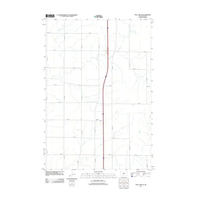
2012 Map of Still Lake NE
USGS Topo · Published 2012About this map
The rolling plains of South Dakota are captured here in a period of modern agricultural organization, defined by the rigid grid of the Public Land Survey System. Traversing the terrain are Indian River and Soo Cr, which provide the primary drainage for this stretch of prairie. This map is a valuable resource for those tracing local burial grounds, as it specifically identifies the Mazeppa Cem located near the intersection of 153rd St and 457th Ave. The landscape is otherwise dominated by a dense network of section-line roads, including 148th St and 460th Ave, illustrating the enduring spatial layout of rural township life in the early 21st century.
Find a feature on this map
18 named features on this map. Tap any name to fly to it.
Don’t see what you’re looking for? This feature index may not catch every label — zoom into the map to look around manually.
Map Details
Editions of this 2012 Still Lake NE Map
This is the sole edition of this map. No revisions or reprints were ever made.
Other maps of this area

1953 · Milbank
USGS Topo · 1:250,000

1958 · Milbank
USGS Topo · 1:250,000

1970 · Summit
USGS Topo · 1:24,000

1970 · Lonesome Lake
USGS Topo · 1:24,000

1970 · Still Lake SE
USGS Topo · 1:24,000

1970 · Marvin
USGS Topo · 1:24,000

1970 · Ortley
USGS Topo · 1:24,000

1970 · Still Lake NE
USGS Topo · 1:24,000

1970 · Still Lake
USGS Topo · 1:24,000
1973 · South Shore
USGS Topo · 1:24,000
Featured Places
- Sunrise Hutterite Colony, Enemy Swim District
- Germantown Township, SD
- Enemy Swim District, SD
- Leola Township, SD
- Big Course District, SD