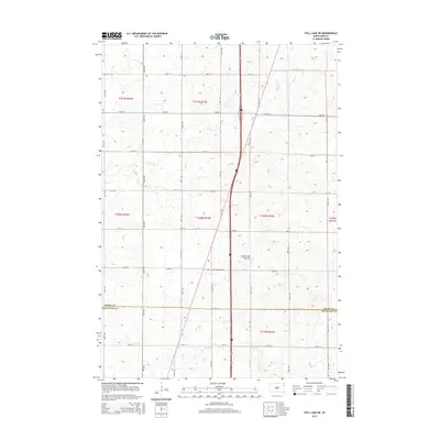
2015 Map of Still Lake NE
USGS Topo · Published 2015About this map
The Coteau des Prairies plateau forms the foundation of this rural landscape, where the northern border of Codington Co meets Grant Co. This mid-2010s survey reveals a classic prairie drainage pattern, with the southward-flowing Indian River and the meandering Soo Cr cutting through the section lines. The geometric grid of rural roads, including 148th St and 155th St, organizes the territory into neat square-mile townships. Near the center of the sheet, the Mazeppa Cem serves as a small but significant landmark for those researching local family ties or the history of early prairie settlements. The map illustrates the persistent structure of agricultural land divisions that have defined this portion of the Dakotas for generations.
Find a feature on this map
18 named features on this map. Tap any name to fly to it.
Don’t see what you’re looking for? This feature index may not catch every label — zoom into the map to look around manually.
Map Details
Editions of this 2015 Still Lake NE Map
This is the sole edition of this map. No revisions or reprints were ever made.
Other maps of this area

1953 · Milbank
USGS Topo · 1:250,000

1958 · Milbank
USGS Topo · 1:250,000

1970 · Summit
USGS Topo · 1:24,000

1970 · Lonesome Lake
USGS Topo · 1:24,000

1970 · Still Lake SE
USGS Topo · 1:24,000

1970 · Marvin
USGS Topo · 1:24,000

1970 · Ortley
USGS Topo · 1:24,000

1970 · Still Lake NE
USGS Topo · 1:24,000

1970 · Still Lake
USGS Topo · 1:24,000
1973 · South Shore
USGS Topo · 1:24,000
Featured Places
- Sunrise Hutterite Colony, Enemy Swim District
- Germantown Township, SD
- Enemy Swim District, SD
- Leola Township, SD
- Big Course District, SD