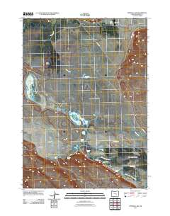
2011 Map of Stinking Lake
USGS Topo · Published 2011About this map
Stinking Lake and the broader Warm Springs Valley define this arid landscape in Harney County, Oregon. The terrain is a complex network of intermittent water sources and small basins, including Tyler Lake, Derrick Lake, and Windmill Pond. Evidence of early agricultural and ranching efforts is visible through human-made modifications like the Saint Clair Canal and Goulden Canal, which attempt to manage the drainage of Silver Creek and various spring-fed systems.
Find a feature on this map
22 named features on this map. Tap any name to fly to it.
Don’t see what you’re looking for? This feature index may not catch every label — zoom into the map to look around manually.
Map Details
Editions of this 2011 Stinking Lake Map
This is the sole edition of this map. No revisions or reprints were ever made.
Other maps of this area

1955 · Burns
USGS Topo · 1:250,000

1958 · Burns
USGS Topo · 1:250,000

1959 · Burns
USGS Topo · 1:250,000

1959 · Dog Mountain
USGS Topo · 1:62,500

1979 · Moon Reservoir
USGS Topo · 1:24,000
1980 · Hughet Spring
USGS Topo · 1:24,000

1980 · Lunch Lake
USGS Topo · 1:24,000

1980 · Iron Mtn. Flat
USGS Topo · 1:24,000
1980 · Southwest Harney Lake
USGS Topo · 1:24,000

1980 · Stinking Lake
USGS Topo · 1:24,000