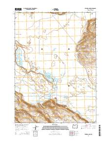
2014 Map of Stinking Lake
USGS Topo · Published 2014About this map
Stinking Lake and the wide expanse of Double O Flat characterize this Harney County landscape, where water management is central to the arid terrain. The map details an intricate network of desert hydrology, including the Goulden Canal and Saint Clair Canal, which deviate from natural flows like Silver Cr and Warm Springs Cr. Numerous vital water sources are documented, such as Double O Cold Spring, Barnyard Spring, and Johnson Spring, which historically supported ranching operations in Warm Springs Valley. Cultural markers like OO Ranch Rd and Big Stick Ln trace the paths of local commerce and land access across the township lines. The presence of Rock Island within the valley floor and the drainage patterns toward Derrick Lake illustrate a complex basin system where every spring and pond was a critical landmark for early settlers and modern land managers alike.
Find a feature on this map
31 named features on this map. Tap any name to fly to it.
Don’t see what you’re looking for? This feature index may not catch every label — zoom into the map to look around manually.
Map Details
Editions of this 2014 Stinking Lake Map
This is the sole edition of this map. No revisions or reprints were ever made.
Other maps of this area

1955 · Burns
USGS Topo · 1:250,000

1958 · Burns
USGS Topo · 1:250,000

1959 · Burns
USGS Topo · 1:250,000

1959 · Dog Mountain
USGS Topo · 1:62,500

1979 · Moon Reservoir
USGS Topo · 1:24,000
1980 · Hughet Spring
USGS Topo · 1:24,000

1980 · Lunch Lake
USGS Topo · 1:24,000

1980 · Iron Mtn. Flat
USGS Topo · 1:24,000
1980 · Southwest Harney Lake
USGS Topo · 1:24,000

1980 · Stinking Lake
USGS Topo · 1:24,000