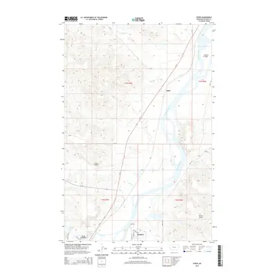
2014 Map of Stipek
USGS Topo · Published 2014About this map
The Yellowstone River serves as the central artery for this portion of Dawson County, carving a wide valley through the eastern Montana landscape. The settlement of Stipek sits along the northern banks, while the growth of Glendive and West Glendive dominates the southern reach of the map. Elevated terrain features like Custers Lookout and Bryants Buttes overlook the river bottomlands, where numerous smaller tributaries including Lower Sevenmile Cr and Deer Creek converge. The area is defined by the transition from river-side agriculture and development to the higher benchlands. Irrigation and water management are evident in features such as Crisafulli Lake and Hollecker Lake, which support the local community. Significant infrastructure, including MT-16, connects these riverside communities and follows the natural corridor created by the river valley.
Find a feature on this map
32 named features on this map. Tap any name to fly to it.
Don’t see what you’re looking for? This feature index may not catch every label — zoom into the map to look around manually.
Map Details
Editions of this 2014 Stipek Map
This is the sole edition of this map. No revisions or reprints were ever made.
Other maps of this area

1909 · Glendive
USGS Topo · 1:250,000

1954 · Glendive
USGS Topo · 1:250,000

1957 · Glendive
USGS Topo · 1:250,000

1958 · Glendive
USGS Topo · 1:250,000

1966 · Kolberg Ranch
USGS Topo · 1:24,000

1966 · Intake
USGS Topo · 1:24,000

1967 · Stipek
USGS Topo · 1:24,000

1967 · Allard
USGS Topo · 1:24,000

1967 · Belle Prairie
USGS Topo · 1:24,000
1967 · Glendive
USGS Topo · 1:24,000