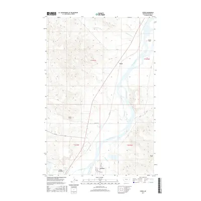
2017 Map of Stipek
USGS Topo · Published 2017About this map
Stipek sits along the western banks of the Yellowstone River north of the regional hub of Glendive, representing a landscape defined by its riparian geometry and high prairie breaks. The river corridor is the dominant geographic feature, creating a system of shifting islands and channels such as Schaffer Island and collecting numerous prairie drainages including Lower Sevenmile Cr, Cotton Cr, and Deer Creek. This 2017 survey details the intersection of early settlement patterns and modern infrastructure, where established township lines like t17n r55e meet arterial routes like Fas 254.
Find a feature on this map
32 named features on this map. Tap any name to fly to it.
Don’t see what you’re looking for? This feature index may not catch every label — zoom into the map to look around manually.
Map Details
Editions of this 2017 Stipek Map
This is the sole edition of this map. No revisions or reprints were ever made.
Other maps of this area

1909 · Glendive
USGS Topo · 1:250,000

1954 · Glendive
USGS Topo · 1:250,000

1957 · Glendive
USGS Topo · 1:250,000

1958 · Glendive
USGS Topo · 1:250,000

1966 · Kolberg Ranch
USGS Topo · 1:24,000

1966 · Intake
USGS Topo · 1:24,000

1967 · Stipek
USGS Topo · 1:24,000

1967 · Allard
USGS Topo · 1:24,000

1967 · Belle Prairie
USGS Topo · 1:24,000
1967 · Glendive
USGS Topo · 1:24,000