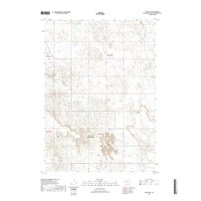
2017 Map of Stirk Table
USGS Topo · Published 2017About this map
Badlands National Park dominates the southern landscape of this Oglala Lakota County terrain, where the sharp erosional features of the White River Badlands meet the expansive high flats. Distinctive plateau formations like Stirk Table and Cuny Table rise above the drainage networks of Cottonwood Creek and North Cottonwood Creek. The path of the Big Foot Trail follows the alignment of BIA Highway 27 through the eastern section, marking a route of profound significance in Lakota history. To the south, the White River winds along the edge of the badlands, joined by tributaries such as Fog Creek near the prominent landmark of Cedar Butte. This map illustrates the transition from the rugged gullies of V-Tail Draw to the broad tables used for grazing and traditional land use within the Pine Ridge Reservation.
Find a feature on this map
14 named features on this map. Tap any name to fly to it.
Don’t see what you’re looking for? This feature index may not catch every label — zoom into the map to look around manually.
Map Details
Editions of this 2017 Stirk Table Map
This is the sole edition of this map. No revisions or reprints were ever made.
Other maps of this area

1950 · Sheep Mountain Table
USGS Topo · 1:24,000

1950 · Stirk Table
USGS Topo · 1:24,000

1950 · Cuny Table East
USGS Topo · 1:24,000

1950 · Imlay SW
USGS Topo · 1:24,000

1950 · Imlay
USGS Topo · 1:24,000

1951 · Sharps Corner
USGS Topo · 1:24,000

1951 · Heutmacher Table
USGS Topo · 1:24,000

1951 · Rockyford NW
USGS Topo · 1:24,000

1951 · Rockyford
USGS Topo · 1:24,000

1955 · Hot Springs
USGS Topo · 1:250,000