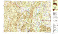
1987 Map of Stockbridge
USGS Topo · Published 1987About this map
The Housatonic River winds through the heart of the Berkshire Hills in the late 1980s, anchoring a landscape where cultural institutions and industrial history sit side-by-side. The world-renowned Tanglewood Auditorium occupies the northern shores of Stockbridge Bowl, while Stockbridge and Lenox maintain their character as established New England centers. To the west, the legacy of the region's iron industry is visible in labels like Hudson Ore Bed Pond and Leet Ore Bed Pond, along with the settlement of Richmond Furnace. These landmarks reflect an era when the extractive economy of the 19th century had transitioned into a premier cultural and residential destination. The Conrail line and the Massachusetts Turnpike provide modern connectivity across the Columbia Co and Berkshire Co line, linking the valley floor to the surrounding heights of Stockbridge Mountain and Lenox Mountain.
Find a feature on this map
79 named features on this map. Tap any name to fly to it.
Don’t see what you’re looking for? This feature index may not catch every label — zoom into the map to look around manually.
Map Details
Editions of this 1987 Stockbridge Map
2 editions found
Other maps of this area

1885 · Sheffield
USGS Topo · 1:62,500

1886 · Becket
USGS Topo · 1:62,500

1888 · Sheffield
USGS Topo · 1:62,500

1888 · Becket
USGS Topo · 1:62,500

1888 · Sandisfield
USGS Topo · 1:62,500

1888 · Pittsfield
USGS Topo · 1:62,500

1890 · Pittsfield
USGS Topo · 1:62,500

1891 · Sheffield
USGS Topo · 1:62,500

1893 · Becket
USGS Topo · 1:62,500

1893 · Sheffield
USGS Topo · 1:62,500