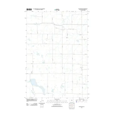
2012 Map of Stockholm
USGS Topo · Published 2012About this map
Troy anchors the western side of this Grant County landscape, where the prairie is defined by a network of drainage sloughs and small glacial lakes. The terrain is dominated by agricultural section lines, yet it preserves significant genealogical markers through its distributed burial grounds. These include Stockholm Cem centrally located near Cemetery Rd, as well as the Troy Cem, Bethel Cem, and Tabor Cem scattered across the township. Hydrological features like Crooked Lake and Pyror Slough interrupt the geometric road grid, illustrating the natural water retention patterns of the region. The N Fork Yellow Bank River meanders through the northern reaches, while routes such as Co Hwy-13 and Co Hwy-28 provide the primary east-west transit across this rural South Dakota expanse.
Find a feature on this map
30 named features on this map. Tap any name to fly to it.
Don’t see what you’re looking for? This feature index may not catch every label — zoom into the map to look around manually.
Map Details
Editions of this 2012 Stockholm Map
This is the sole edition of this map. No revisions or reprints were ever made.
Other maps of this area

1953 · Milbank
USGS Topo · 1:250,000

1953 · Watertown
USGS Topo · 1:250,000

1958 · Milbank
USGS Topo · 1:250,000

1958 · Watertown
USGS Topo · 1:250,000

1970 · Kranzburg
USGS Topo · 1:24,000

1970 · Goodwin
USGS Topo · 1:24,000

1973 · Twin Brooks
USGS Topo · 1:24,000

1973 · LaBolt
USGS Topo · 1:24,000

1973 · Tunerville
USGS Topo · 1:24,000
1973 · Milbank West
USGS Topo · 1:24,000