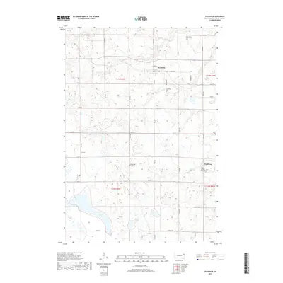
2017 Map of Stockholm
USGS Topo · Published 2017About this map
Coteau des Prairies, the high glacial plateau of eastern South Dakota, defines the terrain of this Grant County survey. The landscape is dotted with numerous small wetlands and sloughs characteristic of the region's post-glacial topography, including Pyror Slough and the waters of Crooked Lake. Settlement is anchored by the small communities of Stockholm, Strandburg, and Troy, which are connected by a grid of agricultural section roads. For those tracing local heritage, the map is remarkably dense with religious and memorial sites, such as the Brown Earth Indian Church and its accompanying Brown Earth Indian Church Cem. These features, along with Tabor Lutheran Church and various family-named burial grounds like Troy Cem and Bethel Cem, provide a detailed record of the cultural and spiritual footprint in this rural farming district.
Find a feature on this map
31 named features on this map. Tap any name to fly to it.
Don’t see what you’re looking for? This feature index may not catch every label — zoom into the map to look around manually.
Map Details
Editions of this 2017 Stockholm Map
This is the sole edition of this map. No revisions or reprints were ever made.
Other maps of this area

1953 · Milbank
USGS Topo · 1:250,000

1953 · Watertown
USGS Topo · 1:250,000

1958 · Milbank
USGS Topo · 1:250,000

1958 · Watertown
USGS Topo · 1:250,000

1970 · Kranzburg
USGS Topo · 1:24,000

1970 · Goodwin
USGS Topo · 1:24,000

1973 · Twin Brooks
USGS Topo · 1:24,000

1973 · LaBolt
USGS Topo · 1:24,000

1973 · Tunerville
USGS Topo · 1:24,000
1973 · Milbank West
USGS Topo · 1:24,000