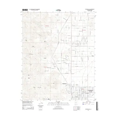
2014 Map of Stockton Hill
USGS Topo · Published 2014About this map
Kingman and its northern residential extensions anchor the southern edge of this Mohave County landscape, where the urban grid of New Kingman -Butler meets the open desert. The terrain is defined by the stark transition from the Hualapai Valley in the east to the high elevations of the Cerbat Mountains in the west. This range is marked by prominent peaks such as Cerbat Peak and Silver Mtn, and dissected by steep drainages like Charcoal Canyon and Johnston Canyon. Historical points of interest include the former mining and ranching sites of Stockton and Stockton Hill, connected by the winding Stockton Hill Rd. The map also illustrates the importance of water management in this arid environment, showing numerous developments and catchments such as Blue Rock Tank and Valley Tank, alongside natural features like Canyon Station Spring and the Thirteenmile Wash.
Find a feature on this map
157 named features on this map. Tap any name to fly to it.
Don’t see what you’re looking for? This feature index may not catch every label — zoom into the map to look around manually.
Map Details
Editions of this 2014 Stockton Hill Map
This is the sole edition of this map. No revisions or reprints were ever made.
Other maps of this area

1886 · Diamond Creek
USGS Topo · 1:250,000

1886 · Camp Mohave
USGS Topo · 1:250,000

1892 · Diamond Creek
USGS Topo · 1:250,000

1892 · Camp Mohave
USGS Topo · 1:250,000

1939 · Chloride
USGS Topo · 1:48,000

1942 · Camp Mohave
USGS Topo · 1:250,000

1944 · Chloride
USGS Topo · 1:62,500

1947 · Kingman
USGS Topo · 1:250,000

1948 · Kingman
USGS Topo · 1:250,000

1948 · Williams
USGS Topo · 1:250,000