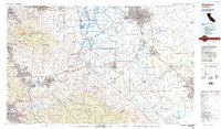
1989 Map of Stockton
USGS Topo · Published 1989About this map
Stockton and Modesto anchor this 1989 topographic overview of the northern San Joaquin Valley and the East Bay's eastern fringes. The landscape is a study in contrasts, moving from the complex waterways of the Sacramento-San Joaquin Delta at Victoria Island and Union Island to the sharp rises of the Black Hills and Mount Diablo. Significant 20th-century infrastructure is prominent, including the Lawrence Livermore Laboratory and the sprawling Sharpe Army Depot.
Find a feature on this map
188 named features on this map. Tap any name to fly to it.
Don’t see what you’re looking for? This feature index may not catch every label — zoom into the map to look around manually.
Map Details
Editions of this 1989 Stockton Map
2 editions found
Other maps of this area

1889 · Jackson
USGS Topo · 1:125,000

1889 · San Jose
USGS Topo · 1:62,500

1892 · Jackson
USGS Topo · 1:125,000

1894 · Lodi
USGS Topo · 1:125,000

1896 · Carquinez Strait
USGS Topo · 1:62,500

1896 · Mt. Diablo
USGS Topo · 1:62,500

1897 · San Jose
USGS Topo · 1:62,500

1897 · Mt. Hamilton
USGS Topo · 1:62,500

1897 · Jackson
USGS Topo · 1:125,000

1897 · Concord
USGS Topo · 1:62,500