Old Maps of San Joaquin County, California
Explore 303 old maps of San Joaquin County, spanning from 1889 to today. These high-resolution historic maps reveal how streets, neighborhoods, landmarks, and natural features evolved over time — perfect for genealogy, metal detecting, research, and local history exploration.
What you can do with these maps:
- See how San Joaquin County changed over time: Compare historical maps to modern-day views to trace roads, homesites, rail lines & more.
- View detailed metadata: Each map includes creators, publishers, year, scale, and archive source.
- Overlay maps with satellite & LiDAR: Visualize the past alongside modern tools to explore terrain & human change.
- Trusted historical sources: Maps sourced from the USGS, Library of Congress, and other archives.
- Access maps your way: View online, download high-res files, or order prints for personal or research use.
Start exploring old maps of San Joaquin County to uncover forgotten places, hidden landmarks, and the deep history beneath your feet.
San Joaquin County, CA maps
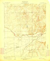
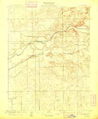
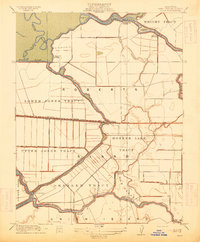
(303)- 1889 Map of Jackson
 1889 Jackson1889 Print · USGSThe Mother Lode foothills thrive in the late nineteenth century as mining and rail expansion reshape the landscape between the San Joaquin Valley and the Sierra Nevada. Genealogists and historians can trace the early layout of Jackson, locate vanished sites like Lancha Plana, and follow the path of the San Joaquin and Sierra Nevada Railroad.
 - 1892 Map of Jackson
 1892 Jackson1892 Print · USGSThe California Gold Country comes alive in the late nineteenth century as mining settlements and river-side camps define the landscape. Genealogists and historians can trace family roots through Mokelumne Hill, San Andreas, and the remote Whiskey Slide.
 - 1894 Map of Lodi
 1894 Lodi1894 Print · USGSThe northern Central Valley and Sierra foothills come alive in the late nineteenth century as railroads reshape the landscape. Local historians can trace early transit hubs like Lodi and Galt alongside rural landmarks like Alabama House and Michigan Bar.3 unique versions available
 - 1897 Map of Jackson
 1897 Jackson1897 Print · USGSAmador and Calaveras counties are shown here during the late nineteenth-century mining era, when the Mother Lode's river-and-rail economy was in full swing. Genealogists can trace family roots through settlements like Mokelumne Hill, San Andreas, and the remote Whiskey Slide.
 - 1902 Map of Jackson
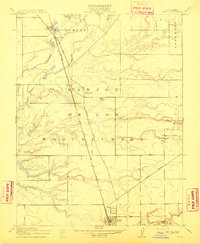
 1902 Jackson1902 Print · USGSAmador and Calaveras counties are captured at the height of the mining era in this late nineteenth-century survey. Genealogists and historians can trace the rail lines of the Stockton and Copperopolis Railroad and find long-established camps like Lancha Plana and Jesus Maria.7 unique versions available
 - 1907 Map of Tesla
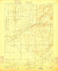
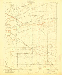
 1907 Tesla1907 Print · USGSThe industrial corridor of Corral Hollow comes to life in this early 1900s survey of the Alameda and San Joaquin border. Genealogists and historians can trace now-quiet locations like Tesla, Pottery, and the Sweet Springs Halfway House along the winding mountain passes.5 unique versions available
 - 1908 Map of Waterloo
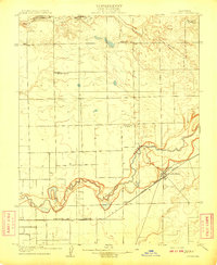
 1908 Waterloo1908 Print · USGSSan Joaquin County at the start of the twentieth century shows a landscape shaped by Mexican land grants and early rail. Trace the historic Campo De Los Franceses boundary, the Central California Traction line, and Greenwood School.2 unique versions available
 - 1908 Map of Linden
 1908 Linden1908 Print · USGSSan Joaquin County agriculture is captured here at the turn of the century as the Central Valley's irrigation patterns began to take shape. Genealogists and local historians can trace early property lines and community hubs like Linden, Bellota, and the Grant School.2 unique versions available
 - 1908 Map of Lockeford
 1908 Lockeford1908 Print · USGSLockeford and the surrounding San Joaquin County plains are shown here at the peak of the rail era. Genealogists can locate family ties at Telegraph School or Brunswick School, and trace the path of the Southern Pacific RR.2 unique versions available
 - 1909 Map of Clay
 1909 Clay1909 Print · USGSCentral Valley ranching and rail life are captured here in the early twentieth century as the county line was being formalized. Genealogists can locate family-named schoolhouses like Alabama School and Laguna School along the Southern Pacific line.2 unique versions available
 - 1909 Map of Goose Creek
 1909 Goose Creek1909 Print · USGSThe foothills where Sacramento, Amador, and San Joaquin counties meet are captured here in the years before the Great War. Genealogists and historians can locate the Hutson School and trace the path of the Southern Pacific R. R. (Amador Branch) alongside Dry Creek.2 unique versions available
 - 1909 Map of Clements
 1909 Clements1909 Print · USGSClements and the Mokelumne River valley appear here in the early twentieth century, showing a landscape defined by ranching and rail. Researchers can locate vanished landmarks like Dogtown, Justice School, and the Southern Pacific R R line.2 unique versions available
 - 1910 Map of New Hope
 1910 New Hope1910 Print · USGSThe California Delta at the start of the twentieth century was a complex network of reclaimed islands and vital waterways. Genealogists and local historians can trace the early community at New Hope and its New Hope School, or locate landings along the Mokelumne River.2 unique versions available
 - 1910 Map of Castle
 1910 Castle1910 Print · USGSThe northern San Joaquin Valley was a landscape of transit and territory during the first decade of the twentieth century. Genealogists and historians can trace the exact routes of Cherokee Lane and the legacy of the Campo De Los Franceses land grant.2 unique versions available
 - 1910 Map of Bouldin
 1910 Bouldin1910 Print · USGSThe Sacramento-San Joaquin Delta at the turn of the century is a labyrinth of reclaimed island tracts and sloughs. Trace the early river landings at Central Landing and Blakes Landing, or locate the Old Cannery along the South Fork Mokelumne River.3 unique versions available
 - 1910 Map of Woodbridge
 1910 Woodbridge1910 Print · USGSSan Joaquin and Sacramento counties are captured here at the height of their early rail-and-river era. Genealogists and historians can trace the early streets of Lodi, the riverside blocks of Woodbridge, and rural landmarks like North School and Tracy Lake.2 unique versions available
 - 1910 Map of Bruceville
 1910 Bruceville1910 Print · USGSThe Sacramento County delta country is captured here in the early twentieth century as a landscape of new railways and traditional wineries. Trace the early days of Bruceville and Bradford Winery, or locate rural landmarks like the Point Pleasant School and Bear Lake.2 unique versions available
 - 1910 Map of Headreach
 1910 Headreach1910 Print · USGSThe California Delta's intricate waterway network is revealed in this 1910 survey, showcasing the early landscape of San Joaquin County. Trace the river economy through landings like Terminous and Headreach Landing or the winding paths of Potato Slough and White Slough.2 unique versions available
 - 1910 Map of Galt
 1910 Galt1910 Print · USGSGalt and the surrounding Sacramento Valley are captured here in the early twentieth century as the railroad transformed rural life. Genealogists and local historians can trace the early rail stops at McConnell and Arno or locate the historic Arno School.2 unique versions available
 - 1910 Map of Isleton
 1910 Isleton1910 Print · USGSThe California Delta's intricate landscape of reclaimed islands and sloughs is captured here just after the turn of the century. You can trace early riverfront settlements like Isleton and Walnut Grove, or locate the waterfront Golden State Cannery.3 unique versions available
 - 1913 Map of Woodward Island
 1913 Woodward Island1913 Print · USGSThe reclaimed islands of the California Delta appear in this pre-war survey as a sophisticated network of levees and rail. Trace early commercial hubs like the Cannery at Woodward and the rural Middle River Moorland P O.
 - 1913 Map of Stockton
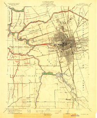 1913 Stockton1913 Print · USGSThe river-port city of Stockton and its surrounding delta tracts come to life in this detailed pre-war survey. Researchers can trace the industrial waterfront and early landings like Crozier's Landing or locate landmarks such as the State Hospital.2 unique versions available
 - 1913 Map of Holt
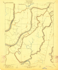
 1913 Holt1913 Print · USGSThe San Joaquin Delta at the height of its reclamation era is captured here, showing the complex lattice of sloughs and leveed tracts. Researchers can locate vanished landings and schools like Blackslough Landing, Eldorado Landing, and Kingston School.2 unique versions available
 - 1913 Map of Romain
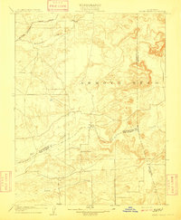
 1913 Romain1913 Print · USGSThe foothills of the Diablo Range meet the San Joaquin Valley floor in the early twentieth century. Researchers can trace early industrial infrastructure like the Southern Pacific R R and Rising Sun School near Romain.
 - 1914 Map of Burnham
 1914 Burnham1914 Print · USGSJust east of Stockton before the First World War, this region shows a landscape of land grants and growing rail junctions. Genealogists can locate family homesteads near Collegeville, Windsor, or rural schoolhouses like Elmwood School and Chartville School.2 unique versions available
Showing maps 1-25 of 303
Top cities of San Joaquin County
- Stockton historical maps
- Tracy historical maps
- Manteca historical maps
- Lodi historical maps
- Mountain House historical maps
- Lathrop historical maps
See more
Frequently asked questions
- What are the different types of historical maps available for San Joaquin County?
- What is the oldest map of San Joaquin County?
- Where can I purchase historical maps of San Joaquin County for my home or office?
- Where can I download high-res historical maps of San Joaquin County?
- Are there historical topographic maps available for San Joaquin County?
- Is there historical aerial imagery available for San Joaquin County?
- Where are historical maps of San Joaquin County sourced from?