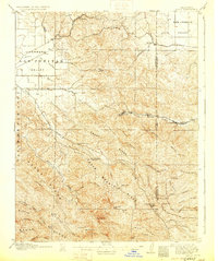
1907 Map of Tesla
USGS Topo · Published 1929About this map
The ridge and canyon country of the Diablo Range dominates this 1907 survey, which captures the industrial activity centered at Corral Hollow. This corridor served as a hub for mining and manufacturing at the turn of the century, evidenced by the clustered settlements of Tesla, Pottery, and Carnegie. The presence of a Gravel Pit and the Western Pacific rail line through this narrow pass underscores the area's role as a vital resource artery connecting the Livermore Valley with the San Joaquin Valley.
Find a feature on this map
53 named features on this map. Tap any name to fly to it.
Don’t see what you’re looking for? This feature index may not catch every label — zoom into the map to look around manually.
Map Details
Editions of this 1907 Tesla Map
5 editions found
Other maps of this area

1889 · San Jose
USGS Topo · 1:62,500

1896 · Mt. Diablo
USGS Topo · 1:62,500

1897 · San Jose
USGS Topo · 1:62,500

1897 · Mt. Hamilton
USGS Topo · 1:62,500

1898 · Mt. Diablo
USGS Topo · 1:62,500

1899 · San Jose
USGS Topo · 1:62,500

1906 · Pleasanton
USGS Topo · 1:62,500

1907 · Tesla
USGS Topo · 1:62,500

1911 · Byron Hot Springs
USGS Topo · 1:31,680

1914 · Bethany
USGS Topo · 1:31,680