
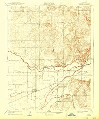
1908 Map of Linden
USGS Topo · Published 1908About this map
Agricultural development along the Calaveras River defines this 1908 San Joaquin County landscape, surveyed just as irrigation and orchard planting were reshaping the Central Valley. The settlement of Linden appears at the center of a developing road network, while further east, Bellota sits at a strategic bend in the river near the Bellota School. The topographic survey, overseen by State Engineer Nathaniel Ellery, captures the transition from the rolling hills in the northeast to the flatter alluvial plains to the southwest. Key water features like Mormon Slough and Duck Creek illustrate the natural drainage patterns that local farmers navigated at the turn of the century. Rural education is anchored by landmarks such as the Grant School, reflecting the community structure of early twentieth-century California ranching and farming districts.
Find a feature on this map
7 named features on this map. Tap any name to fly to it.
Don’t see what you’re looking for? This feature index may not catch every label — zoom into the map to look around manually.
Map Details
Editions of this 1908 Linden Map
2 editions found
Other maps of this area

1889 · Jackson
USGS Topo · 1:125,000

1892 · Jackson
USGS Topo · 1:125,000

1894 · Lodi
USGS Topo · 1:125,000

1897 · Jackson
USGS Topo · 1:125,000

1902 · Jackson
USGS Topo · 1:125,000

1908 · Waterloo
USGS Topo · 1:31,680

1908 · Lockeford
USGS Topo · 1:31,680

1909 · Clements
USGS Topo · 1:31,680

1914 · Burnham
USGS Topo · 1:31,680

1915 · Trigo
USGS Topo · 1:31,680