1894 Map of Lodi
USGS Topo · Published 1906About this map
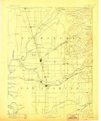
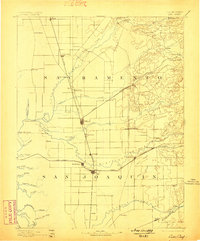
The Cosumnes River and Mokelumne River define the agrarian landscape of the Central Valley at the end of the nineteenth century. This topography reveals a complex network of waterways, including Tracy Lake and the winding Twenty One Mile Slough, which shaped early settlement patterns and transport. Rail dominance is evident through the path of the Central Pacific Railroad connecting major hubs like Elk Grove, Galt, and Lodi. The interior is dotted with historical waypoints such as Slough House and Alabama House, while Benson Bridge and New Hope Landing mark vital crossing and docking points for a region still heavily reliant on its river systems. Researchers can trace the early jurisdictional lines between Sacramento and San Joaquin as they follow the meanders of these critical California watersheds.
Find a feature on this map
62 named features on this map. Tap any name to fly to it.
Don’t see what you’re looking for? This feature index may not catch every label — zoom into the map to look around manually.
Map Details
Editions of this 1894 Lodi Map
3 editions found
Other maps of this area

1889 · Jackson
USGS Topo · 1:125,000

1891 · Sacramento
USGS Topo · 1:125,000

1891 · Placerville
USGS Topo · 1:125,000

1892 · Jackson
USGS Topo · 1:125,000

1892 · Sacramento
USGS Topo · 1:125,000

1892 · Placerville
USGS Topo · 1:125,000

1893 · Placerville
USGS Topo · 1:125,000

1893 · Sacramento
USGS Topo · 1:125,000

1894 · Lodi
USGS Topo · 1:125,000

1897 · Jackson
USGS Topo · 1:125,000