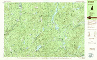
1984 Map of Stoddard
USGS Topo · Published 1984About this map
Highland Lake and the surrounding woodlands of Cheshire County dominate this landscape as it appeared in the early 1980s. The area is characterized by scattered lakeside settlements and small hamlets such as Mill Village and South Stoddard, connected by winding roads through heavy forest cover. The prominence of protected lands like Pitcher Mtn State Forest and the Kenyon Tract Wildlife Management Area underscores the region's character as a conservation-focused highland. Local history is etched into the terrain at Joslin Hill and the nearby Joslin Cem, while remnants of industry appear at Woods Mill along the western edge of Stoddard. For those tracing the evolution of outdoor recreation, the Monadnock-Sunapee Trail is clearly delineated as it traverses the ridges, passing landmarks like Stoddard Rocks. The map also captures the headwaters of the Ashuelot River and several significant reservoirs including Robb Reservoir and Ellis Reservoir.
Find a feature on this map
108 named features on this map. Tap any name to fly to it.
Don’t see what you’re looking for? This feature index may not catch every label — zoom into the map to look around manually.
Map Details
Editions of this 1984 Stoddard Map
This is the sole edition of this map. No revisions or reprints were ever made.
Other maps of this area

1898 · Monadnock
USGS Topo · 1:62,500

1898 · Keene
USGS Topo · 1:62,500

1900 · Peterboro
USGS Topo · 1:62,500

1926 · Hillsboro
USGS Topo · 1:62,500

1927 · Bellows Falls
USGS Topo · 1:48,000

1929 · Hillsboro
USGS Topo · 1:62,500

1930 · Lovewell Mountain
USGS Topo · 1:62,500

1930 · Bellows Falls
USGS Topo · 1:62,500

1932 · Keene
USGS Topo · 1:62,500
1935 · Keene
USGS Topo · 1:62,500