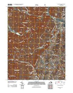
2011 Map of Stokesville
USGS Topo · Published 2011About this map
Stokesville anchors this landscape where the North River cuts through the mountains, marking a transition between the high ridges and the agricultural foothills. The area is defined by water management and outdoor recreation, featuring several infrastructure projects including Staunton Dam, Upper North River Number 10 Dam, and Upper North River Number 76 Dam. These structures support Elkhorn Lake and provide flood control for the settlements downstream.
Find a feature on this map
75 named features on this map. Tap any name to fly to it.
Don’t see what you’re looking for? This feature index may not catch every label — zoom into the map to look around manually.
Map Details
Editions of this 2011 Stokesville Map
This is the sole edition of this map. No revisions or reprints were ever made.
Other maps of this area

1894 · Staunton
USGS Topo · 1:125,000

1924 · Mc Dowell
USGS Topo · 1:62,500

1943 · Craigsville
USGS Topo · 1:62,500

1944 · Parnassus
USGS Topo · 1:62,500

1944 · Mc Dowell
USGS Topo · 1:62,500

1944 · Staunton
USGS Topo · 1:62,500

1945 · Craigsville
USGS Topo · 1:62,500

1946 · Mc Dowell
USGS Topo · 1:62,500

1947 · Staunton
USGS Topo · 1:62,500

1947 · Parnassus
USGS Topo · 1:62,500