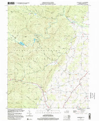
1999 Map of Stokesville
USGS Topo · Published 2000About this map
Stokesville stands at the eastern edge of the George Washington Forest, where the North River and Little River meet at the North River Gap. This region of Augusta County is defined by the heavy presence of public lands and water management infrastructure, most notably the Staunton Dam and the North River Campground. The map illustrates a landscape of high ridges and hollows, such as Trimble Mountain and Lookout Mountain, where drainage patterns like White Oak Draft and Freemason Hollow carve into the terrain.
Find a feature on this map
58 named features on this map. Tap any name to fly to it.
Don’t see what you’re looking for? This feature index may not catch every label — zoom into the map to look around manually.
Map Details
Editions of this 1999 Stokesville Map
This is the sole edition of this map. No revisions or reprints were ever made.
Other maps of this area

1894 · Staunton
USGS Topo · 1:125,000

1924 · Mc Dowell
USGS Topo · 1:62,500

1943 · Craigsville
USGS Topo · 1:62,500

1944 · Parnassus
USGS Topo · 1:62,500

1944 · Mc Dowell
USGS Topo · 1:62,500

1944 · Staunton
USGS Topo · 1:62,500

1945 · Craigsville
USGS Topo · 1:62,500

1946 · Mc Dowell
USGS Topo · 1:62,500

1947 · Staunton
USGS Topo · 1:62,500

1947 · Parnassus
USGS Topo · 1:62,500