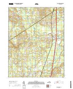
2019 Map of Stony Creek
USGS Topo · Published 2019About this map
The town of Stony Creek sits as a central hub in this Southern Virginia landscape, defined by a complex network of wetlands and tributaries. The terrain is characterized by expansive drainage systems such as Peaquarter Swamp, Galley Swamp, and Southwest Swamp, which feed into the larger Nottoway River at the southern boundary. These wetlands dictate the placement of local settlements and infrastructure, with Winfields Mill and Huske established on the drier ground between the forks. Local genealogy and community history are anchored by landmarks like the Pegram Cem, Sappony Cem, and the Green Church Bridge crossing. The map reveals how the modern transportation corridor bisects the older rural fabric, cutting through areas like Fort Nottoway while preserving the names of historic family roads such as Mortar Branch Rd and Jones Branch Rd.
Find a feature on this map
75 named features on this map. Tap any name to fly to it.
Don’t see what you’re looking for? This feature index may not catch every label — zoom into the map to look around manually.
Map Details
Editions of this 2019 Stony Creek Map
This is the sole edition of this map. No revisions or reprints were ever made.
Other maps of this area

1894 · Petersburg
USGS Topo · 1:62,500

1897 · Amelia
USGS Topo · 1:125,000

1919 · Jarratt
USGS Topo · 1:62,500

1919 · Mc Kenney
USGS Topo · 1:48,000

1921 · Mc Kenney
USGS Topo · 1:62,500

1943 · Mc Kenney
USGS Topo · 1:62,500

1943 · Dinwiddie
USGS Topo · 1:24,000

1943 · Richmond
USGS Topo · 1:250,000

1944 · Reams
USGS Topo · 1:31,680
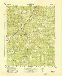
1944 · Dinwiddie
USGS Topo · 1:31,680