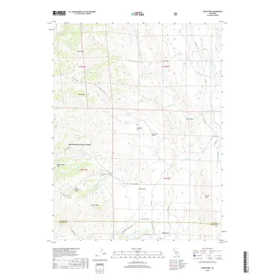
2018 Map of Stonyford
USGS Topo · Published 2018About this map
Stonyford sits at the southern edge of this survey, marking a point of transition where the foothills of the Coast Range meet the floor of Indian Valley. The landscape is defined by the complex hydrology of the western Sacramento Valley watershed, notably the convergence of Stony Creek and Little Stony Cr. To the west, the boundary of the Mendocino National Forest encompasses high-elevation features like the Black Diamond Ridge and the Black Diamond Glades, connected by a network of forest routes including Black Diamond Rd. The map illustrates a rural interior economy dependent on these water sources and access roads, such as Lodoga Stonyford Rd and Co Rd 306. This area remains characterized by its ridges, including Auk Auk Ridge and Gravelly Ridge, which flank the narrow valleys and seasonal drainages like Salt Cr and Briscoe Cr.
Find a feature on this map
41 named features on this map. Tap any name to fly to it.
Don’t see what you’re looking for? This feature index may not catch every label — zoom into the map to look around manually.
Map Details
Editions of this 2018 Stonyford Map
This is the sole edition of this map. No revisions or reprints were ever made.
Other maps of this area

1919 · Fruto
USGS Topo · 1:62,500

1919 · Elk Creek
USGS Topo · 1:62,500

1943 · Lodoga
USGS Topo · 1:62,500

1944 · Fruto
USGS Topo · 1:62,500

1948 · Elk Creek
USGS Topo · 1:62,500

1951 · Stonyford
USGS Topo · 1:62,500

1957 · Elk Creek
USGS Topo · 1:62,500

1957 · Ukiah
USGS Topo · 1:250,000
1958 · Fruto
USGS Topo · 1:62,500

1960 · Ukiah
USGS Topo · 1:250,000