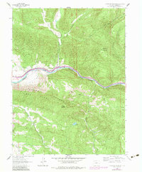
1962 Map of Storm King Mountain
USGS Topo · Published 1984About this map
The Colorado River carves through this dramatic landscape, accompanied by the critical transit corridor of the Denver and Rio Grande Western railroad. The topography is dominated by the massive Grand Hogback and Storm King Mountain, creating a natural bottleneck for early transportation and communication lines. Near the confluence of Canyon Creek and the river, the presence of the Canyon Creek Sch and Okanela Lodge indicates a localized cluster of settlement and early mountain recreation. Rural industry and water management are evident at Porter Reservoir and a designated Mine, while the northern reaches of the map show an extensive Stock Driveway following the drainages of Canyon Creek and Bearwallow Creek, reflecting the importance of livestock movement in the high country.
Find a feature on this map
22 named features on this map. Tap any name to fly to it.
Don’t see what you’re looking for? This feature index may not catch every label — zoom into the map to look around manually.
Map Details
Editions of this 1962 Storm King Mountain Map
4 editions found

Other maps of this area

1906 · Grand Hogback
USGS Topo · 1:125,000

1910 · Grand Hogback
USGS Topo · 1:125,000

1927 · Glenwood Springs
USGS Topo · 1:125,000

1930 · Glenwood Springs
USGS Topo · 1:125,000

1957 · Leadville
USGS Topo · 1:250,000

1959 · Leadville
USGS Topo · 1:250,000

1960 · Leadville
USGS Topo · 1:250,000

1961 · Cattle Creek
USGS Topo · 1:24,000

1961 · Glenwood Springs
USGS Topo · 1:24,000

1962 · Leadville
USGS Topo · 1:250,000