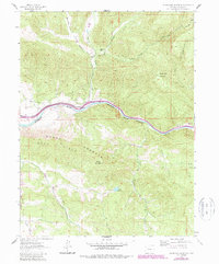
1962 Map of Storm King Mountain
USGS Topo · Published 1988About this map
Storm King Mountain and the massive uplift of the Grand Hogback dominate this landscape, where the Colorado River cuts a deep path through the canyon country of Garfield County. The corridor along the river serves as the primary artery for transportation, carrying the tracks of the Denver & Rio Grande Western railroad. Evidence of early settlement and industry is scattered through the drainages, including the Canyon Creek Sch and small extraction sites like Mina and other unnamed mines tucked into the ridges. To the south, the Garfield Creek State Wildlife Area encompasses the rugged basins around Horse Mountain and Alkali Creek. The map reflects a mid-century transition in land use, featuring legacy structures like Okafelia Lodge alongside water management infrastructure such as Porter Reservoir and several named ditches that divert snowmelt from the high peaks to the valley floor.
Find a feature on this map
29 named features on this map. Tap any name to fly to it.
Don’t see what you’re looking for? This feature index may not catch every label — zoom into the map to look around manually.
Map Details
Editions of this 1962 Storm King Mountain Map
4 editions found

Other maps of this area

1906 · Grand Hogback
USGS Topo · 1:125,000

1910 · Grand Hogback
USGS Topo · 1:125,000

1927 · Glenwood Springs
USGS Topo · 1:125,000

1930 · Glenwood Springs
USGS Topo · 1:125,000

1957 · Leadville
USGS Topo · 1:250,000

1959 · Leadville
USGS Topo · 1:250,000

1960 · Leadville
USGS Topo · 1:250,000

1961 · Cattle Creek
USGS Topo · 1:24,000

1961 · Glenwood Springs
USGS Topo · 1:24,000

1962 · Leadville
USGS Topo · 1:250,000