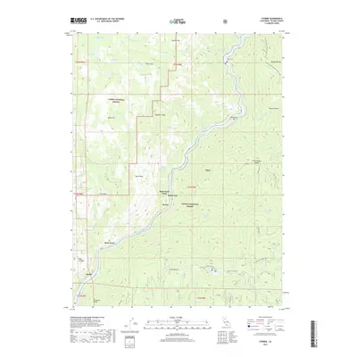
2018 Map of Storrie
USGS Topo · Published 2018About this map
The North Fork Feather River carves a deep canyon through this portion of the northern Sierra Nevada, serving as the primary corridor for both the railroad and several small riverside settlements. This 2018 survey documents the small communities and infrastructure clinging to the steep slopes, including Storrie, Tobin, and Merlin. The rugged landscape is divided between the Lassen National Forest to the northwest and the Plumas National Forest to the southeast, with high-elevation features like Chambers Peak and Elephant Butte defining the skyline. For those interested in recreation and mountain geography, the Pacific Crest National Scenic Trail winds through the northeastern corner near Belden Ravine, while numerous small lakes like Campbell Lake and Grassy Lake occupy the higher benches above the river canyon. The map reveals the intricate engineering required to navigate this terrain, highlighted by the presence of Tunnel 17 and a network of Forest Service spurs.
Find a feature on this map
58 named features on this map. Tap any name to fly to it.
Don’t see what you’re looking for? This feature index may not catch every label — zoom into the map to look around manually.
Map Details
Editions of this 2018 Storrie Map
This is the sole edition of this map. No revisions or reprints were ever made.
Other maps of this area

1886 · Lassen Peak
USGS Topo · 1:250,000

1888 · Bidwell Bar
USGS Topo · 1:125,000

1891 · Bidwell Bar
USGS Topo · 1:125,000

1892 · Lassen Peak
USGS Topo · 1:250,000

1893 · Bidwell Bar
USGS Topo · 1:125,000

1894 · Lassen Peak
USGS Topo · 1:250,000

1895 · Bidwell Bar
USGS Topo · 1:125,000

1897 · Bidwell Bar
USGS Topo · 1:125,000

1950 · Bucks Lake
USGS Topo · 1:62,500

1955 · Almanor
USGS Topo · 1:62,500