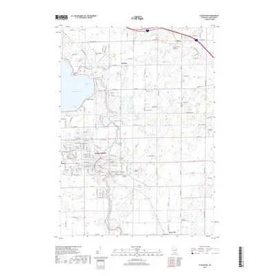
2018 Map of Stoughton
USGS Topo · Published 2018About this map
The Yahara River winds through this landscape, connecting Lake Kegonsa to the industrial and residential corridors of Stoughton. This contemporary survey highlights the community's evolution along the water, where the Stoughton Millpond 429 and Dunkirk Millpond 442 define the river's flow through town. The map is particularly rich for genealogical research, documenting numerous burial sites including the West Koshkonong Lutheran Church Cem, Saint Ann Catholic Cem, and the Skaalen Cem. Beyond the urban center, the terrain transitions into the rural reaches of Hanerville and the residential clusters of Kegonsa. Transportation and local infrastructure are marked by features like Matson Airport and Wisersky Airport, while several family-named landmarks like Williams Point and Nichols Point dot the shoreline of the bay, reflecting long-standing patterns of land use and settlement in Dane County.
Find a feature on this map
146 named features on this map. Tap any name to fly to it.
Don’t see what you’re looking for? This feature index may not catch every label — zoom into the map to look around manually.
Map Details
Editions of this 2018 Stoughton Map
This is the sole edition of this map. No revisions or reprints were ever made.
Other maps of this area

1889 · Evansville
USGS Topo · 1:62,500

1890 · Madison
USGS Topo · 1:62,500

1890 · Sun Prairie
USGS Topo · 1:62,500

1890 · Stoughton
USGS Topo · 1:62,500

1892 · Madison
USGS Topo · 1:62,500

1894 · Evansville
USGS Topo · 1:62,500

1896 · Sun Prairie
USGS Topo · 1:62,500

1904 · Madison
USGS Topo · 1:62,500

1905 · Sun Prairie
USGS Topo · 1:62,500

1906 · Evansville
USGS Topo · 1:62,500