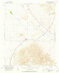
1952 Map of Stovepipe Wells
USGS Topo · Published 1961About this map
Stovepipe Wells Hotel and its adjacent landing strip serve as the primary human foothold in this 1952 topographic study of central Death Valley. The landscape is defined by the stark transition from the towering Tucki Mountain and Grapevine Mountains to the low-lying Death Valley (Depression). Notable features include the shifting Mesquite Flat Sand Dunes and the curiously named Devils Cornfield, alongside vital but sparse water sources like Midway Well and the non-potable McLean Spring. Historical transit corridors are clearly marked, including the Old Emigrant Route, a Toll Road, and a network of jeep trails that navigate through narrow passages such as Grotto Canyon and Mosaic Canyon. This survey captures the region during a period of increasing accessibility within the Death Valley National Monument while the area still retained its primitive, unpaved character.
Find a feature on this map
22 named features on this map. Tap any name to fly to it.
Don’t see what you’re looking for? This feature index may not catch every label — zoom into the map to look around manually.
Map Details
Editions of this 1952 Stovepipe Wells Map
4 editions found
Other maps of this area

1908 · Furnace Creek
USGS Topo · 1:250,000

1908 · Ballarat
USGS Topo · 1:250,000

1910 · Furnace Creek
USGS Topo · 1:250,000

1913 · Ballarat
USGS Topo · 1:250,000

1942 · Bullfrog
USGS Topo · 1:125,000

1948 · Death Valley
USGS Topo · 1:250,000

1951 · Panamint Butte
USGS Topo · 1:62,500

1951 · Marble Canyon
USGS Topo · 1:62,500

1952 · Chloride Cliff
USGS Topo · 1:50,000

1952 · Stovepipe Wells
USGS Topo · 1:62,500