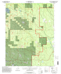
1995 Map of Stover Mountain
USGS Topo · Published 1998About this map
Lassen National Forest terrain dominates this mid-1990s survey, illustrating a landscape defined by forest management and outdoor recreation. The map traces the Pacific Crest National Scenic Trail as it winds through the high country past Stover Mountain and the headwaters of the North Fork Feather River. Human presence is marked by small enclaves such as Willow Creek Homesite and Feather River Homesite, along with the settlement of St Bernard to the south.
Find a feature on this map
44 named features on this map. Tap any name to fly to it.
Don’t see what you’re looking for? This feature index may not catch every label — zoom into the map to look around manually.
Map Details
Editions of this 1995 Stover Mountain Map
This is the sole edition of this map. No revisions or reprints were ever made.
Other maps of this area

1886 · Lassen Peak
USGS Topo · 1:250,000

1892 · Lassen Peak
USGS Topo · 1:250,000

1894 · Lassen Peak
USGS Topo · 1:250,000

1955 · Almanor
USGS Topo · 1:62,500

1955 · Westwood
USGS Topo · 1:250,000

1956 · Mt. Harkness
USGS Topo · 1:62,500

1956 · Chester
USGS Topo · 1:62,500

1958 · Westwood
USGS Topo · 1:250,000

1958 · Jonesville
USGS Topo · 1:62,500

1959 · Westwood
USGS Topo · 1:250,000