1896 Map of Strafford
USGS Topo · Published 1943About this map
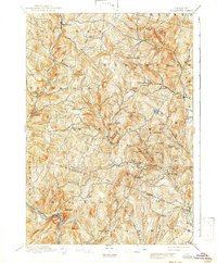
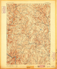
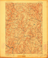
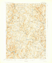
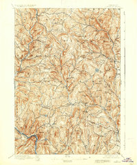
Copperfield and Copper Flat reveal a landscape deeply influenced by Vermont's 19th-century mining economy, particularly near the town of Vershire. This 1894 survey, reprinted during the war, documents a network of highland settlements and river valley mills connected by the Central Vermont railroad along the White River. The topography is dominated by local landmarks like Gile Mtn. and Patterson Mtn., while water power drives the development of sites like Mill Village and Rices Mills along the Ompompanoosuc River. These named hills and brooks create a dense map of agrarian and industrial activity, including smaller hamlets like Post Mills and Union Village. The map serves as a record of the region's historical geography before the consolidation of these smaller rural centers, capturing specific family-named heights such as Kibling Hill and Grannyhand Hill that offer a detailed view for genealogists.
Find a feature on this map
88 named features on this map. Tap any name to fly to it.
Don’t see what you’re looking for? This feature index may not catch every label — zoom into the map to look around manually.
Map Details
Editions of this 1896 Strafford Map
6 editions found
Other maps of this area

1896 · Strafford
USGS Topo · 1:62,500

1906 · Hanover
USGS Topo · 1:62,500

1908 · Hanover
USGS Topo · 1:62,500

1911 · Woodstock
USGS Topo · 1:62,500

1913 · Woodstock
USGS Topo · 1:62,500

1919 · Royalton
USGS Topo · 1:62,500

1922 · Barre
USGS Topo · 1:48,000

1924 · Barre
USGS Topo · 1:62,500

1924 · Randolph
USGS Topo · 1:48,000

1926 · Randolph
USGS Topo · 1:62,500