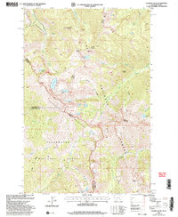
1999 Map of Straight Peak
USGS Topo · Published 2004About this map
The Bitterroot Mountains define the high-altitude divide on this late 20th-century survey, marking the state border where Montana Idaho meet. This terrain is characterized by a high density of alpine water bodies, including the Trio Lakes, Hidden Lake, and the geographically central Heart Lake. The landscape is managed as part of the Lolo National Forest and Clearwater National Forest, where the topography drops sharply from summits like Straight Peak and Lightning Peak into narrow drainages such as Fletcher Gulch and Snowy Gulch. The complex network of water features, from Crater Lake to the headwaters of South Fork Trout Creek, illustrates a pristine wilderness environment before the turn of the millennium. Surveyed boundaries for Mineral, Shoshone, and Clearwater counties intersect here, reflecting the remote nature of these political divisions in the high backcountry.
Find a feature on this map
35 named features on this map. Tap any name to fly to it.
Don’t see what you’re looking for? This feature index may not catch every label — zoom into the map to look around manually.
Map Details
Editions of this 1999 Straight Peak Map
This is the sole edition of this map. No revisions or reprints were ever made.
Other maps of this area

1911 · Lolo
USGS Topo · 1:250,000

1913 · Lolo
USGS Topo · 1:250,000

1918 · St Regis
USGS Topo · 1:125,000

1919 · St. Regis
USGS Topo · 1:125,000

1956 · Wallace
USGS Topo · 1:250,000

1956 · Hamilton
USGS Topo · 1:250,000

1957 · Illinois Peak
USGS Topo · 1:62,500

1959 · Hamilton
USGS Topo · 1:250,000

1960 · Wallace
USGS Topo · 1:250,000

1960 · Hamilton
USGS Topo · 1:250,000