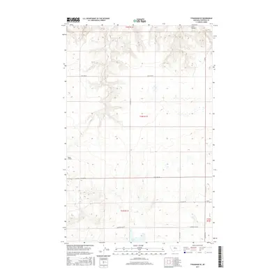
2017 Map of Stranahan SE
USGS Topo · Published 2017About this map
Clear Lake sits as a central landmark in this high plains landscape of Chouteau County, where the terrain is defined by the carved drainage patterns of Crow Coulee to the north and Rowe Coulee to the west. The layout of the land reflects the systematic grid of the Public Land Survey System, with section lines and rural thoroughfares like Enterprise Rd and Danbrook Rd providing structure to the open ranchland. Near the intersection of Clear Lake Rd and Geraldine Rd N lies the Clear Lake Cem, a significant site for local family history and genealogical research in this sparsely settled region. To the south, Hardwood Lake Rd and Ric Oshay Rd traverse the rolling topography, illustrating the enduring transport network that connects isolated farmsteads across the Montana prairie.
Find a feature on this map
15 named features on this map. Tap any name to fly to it.
Don’t see what you’re looking for? This feature index may not catch every label — zoom into the map to look around manually.
Map Details
Editions of this 2017 Stranahan SE Map
This is the sole edition of this map. No revisions or reprints were ever made.
Other maps of this area

1890 · Fort Benton
USGS Topo · 1:250,000

1892 · Fort Benton
USGS Topo · 1:250,000

1897 · Fort Benton
USGS Topo · 1:250,000

1953 · Rocky Lake
USGS Topo · 1:24,000

1953 · Loma East
USGS Topo · 1:24,000

1953 · Big Bend School
USGS Topo · 1:24,000

1953 · Stranahan
USGS Topo · 1:24,000

1954 · Great Falls
USGS Topo · 1:250,000

1957 · Great Falls
USGS Topo · 1:250,000
1972 · Eagle Buttes SW
USGS Topo · 1:24,000