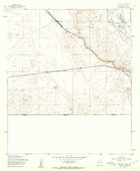
1955 Map of Strauss
USGS Topo · Published 1962About this map
The Southern Pacific railroad corridor dominates this high-desert landscape near the border, anchoring a series of small outposts and rail-stop settlements. At Strauss, the rail line angles through a series of dramatic contour shifts as it approaches the Mesilla Valley and the prominent rising terrain of Santa Teresa. The settlement of Orange and the Santa Nina Ch represent the localized agrarian and community life near the New Mexico-Texas boundary line, where water management via the La Union Canal and West Drain was essential for cultivation. Further south, an Old Railroad Grade and isolated labels like Mastodon and Lizard mark the sparse, arid reaches leading down to the international border with Mexico.
Find a feature on this map
19 named features on this map. Tap any name to fly to it.
Don’t see what you’re looking for? This feature index may not catch every label — zoom into the map to look around manually.
Map Details
Editions of this 1955 Strauss Map
This is the sole edition of this map. No revisions or reprints were ever made.
Other maps of this area

1917 · Canutillo
USGS Topo · 1:62,500

1917 · Noria
USGS Topo · 1:62,500

1918 · Noria
USGS Topo · 1:62,500

1919 · Canutillo
USGS Topo · 1:62,500

1953 · El Paso
USGS Topo · 1:250,000
1955 · Smeltertown
USGS Topo · 1:24,000
1955 · Canutillo
USGS Topo · 1:24,000
1955 · La Union
USGS Topo · 1:24,000

1959 · El Paso
USGS Topo · 1:250,000

1964 · El Paso
USGS Topo · 1:250,000