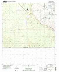
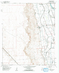
1996 Map of Strauss
USGS Topo · Published 2002About this map
The Mesilla Valley serves as a stark transition point in this borderland landscape, where the irrigated agriculture of the Rio Grande basin meets the arid desert of southern New Mexico. Near the international boundary with Chihuahua, the map documents a mix of infrastructure and remote outposts, including the settlement of Strauss and the Dona Ana County at Santa Teresa Airport. Residential and institutional growth is evident at the Santa Teresa Jr High Sch and nearby Golf Course, contrasted by the more industrial presence of a Sewage Disposal site and a large Feedlot. Local history is captured in the remnants of transportation networks, specifically the Old Railroad Grade that cuts across the terrain toward the southeastern corner near Lizard. These features, alongside landmarks like Mastadon, reflect the complex land use at the intersection of Texas, New Mexico, and Mexico.
Find a feature on this map
21 named features on this map. Tap any name to fly to it.
Don’t see what you’re looking for? This feature index may not catch every label — zoom into the map to look around manually.
Map Details
Editions of this 1996 Strauss Map
This is the sole edition of this map. No revisions or reprints were ever made.
Other maps of this area

1917 · Canutillo
USGS Topo · 1:62,500

1917 · Noria
USGS Topo · 1:62,500

1918 · Noria
USGS Topo · 1:62,500

1919 · Canutillo
USGS Topo · 1:62,500

1953 · El Paso
USGS Topo · 1:250,000
1955 · Smeltertown
USGS Topo · 1:24,000
1955 · Strauss
USGS Topo · 1:24,000
1955 · Canutillo
USGS Topo · 1:24,000
1955 · La Union
USGS Topo · 1:24,000

1959 · El Paso
USGS Topo · 1:250,000