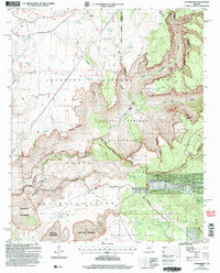
2004 Map of Strawberry
USGS Topo · Published 2006About this map
Strawberry sits at the foot of the Mogollon Rim, a dramatic geological escarpment that defines the transition between high plateau and deep canyon country. This 2004 revision shows the town and its surrounding wilderness at a time when traditional ranching at Lazy T-7 Ranch shared the landscape with growing recreation. The General George Crook National Recreation Trail traces a path across the northern plateau, following a historic military route that predates the modern forest boundaries.
Find a feature on this map
57 named features on this map. Tap any name to fly to it.
Don’t see what you’re looking for? This feature index may not catch every label — zoom into the map to look around manually.
Map Details
Editions of this 2004 Strawberry Map
This is the sole edition of this map. No revisions or reprints were ever made.
Other maps of this area

1887 · Verde
USGS Topo · 1:250,000

1892 · Verde
USGS Topo · 1:250,000

1923 · Camp Verde
USGS Topo · 1:125,000

1929 · Turret Peak
USGS Topo · 1:125,000

1932 · Camp Verde
USGS Topo · 1:125,000

1933 · Turret Peak
USGS Topo · 1:125,000

1934 · Pine
USGS Topo · 1:62,500

1936 · Camp Verde
USGS Topo · 1:125,000

1940 · Pine
USGS Topo · 1:62,500

1952 · Pine
USGS Topo · 1:62,500