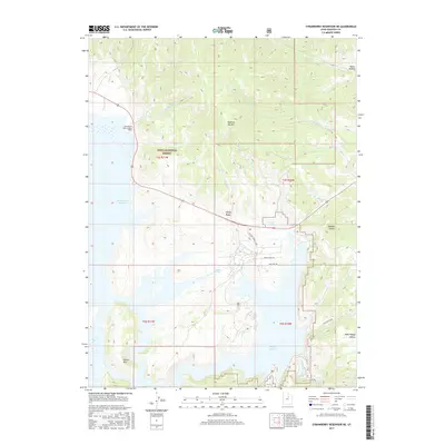
2017 Map of Strawberry Reservoir NE
USGS Topo · Published 2017About this map
The northern waters of Strawberry Reservoir dominate this high-elevation landscape within the Uinta National Forest. The map documents a sophisticated water management system, most notably the Water Hollow Tunnel and its West Portal, designed to divert water through the mountains. Topographical highlights include the prominent Island Mtn rising from the reservoir's western reaches and Square Top Mtn overlooking the drainages of N Fork Deep Cr.
Find a feature on this map
30 named features on this map. Tap any name to fly to it.
Don’t see what you’re looking for? This feature index may not catch every label — zoom into the map to look around manually.
Map Details
Editions of this 2017 Strawberry Reservoir NE Map
This is the sole edition of this map. No revisions or reprints were ever made.
Other maps of this area

1885 · Salt Lake
USGS Topo · 1:250,000

1885 · Uinta
USGS Topo · 1:250,000

1907 · Strawberry Valley
USGS Topo · 1:125,000

1909 · Strawberry Valley
USGS Topo · 1:125,000

1954 · Salt Lake City
USGS Topo · 1:250,000

1958 · Salt Lake City
USGS Topo · 1:250,000

1960 · Salt Lake City
USGS Topo · 1:250,000

1962 · Deep Creek Canyon
USGS Topo · 1:24,000

1962 · Raspberry Knoll
USGS Topo · 1:24,000
1962 · Strawberry Peak
USGS Topo · 1:24,000