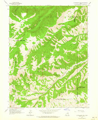
1962 Map of Strawberry Peak
USGS Topo · Published 1964About this map
Ashley National Forest and Uinta National Forest meet in this high-altitude landscape of the early 1960s, defined by a complex network of deep drainages and ridges. The topography is dominated by the massive Beaver Canyon to the north and the expansive Timber Canyon system to the south, separated by the strikingly named Twelve Hundred Dollar Ridge. The Old Indian Treaty Boundary cuts across the terrain, serving as a reminder of the region's historical land divisions. Economic activity is sparse but present, notably at a single Oil Well located south of Jackson Hollow. The map meticulously details the high-country hydrology, from the Strawberry River in the north to the perennial flow of Big Beaver Springs and the headwaters of Minnie Creek. Navigation during this era relied heavily on primitive infrastructure, represented by the numerous Jeep Trails and unnamed foot trails that traverse the steep slopes of Strawberry Peak.
Find a feature on this map
26 named features on this map. Tap any name to fly to it.
Don’t see what you’re looking for? This feature index may not catch every label — zoom into the map to look around manually.
Map Details
Editions of this 1962 Strawberry Peak Map
This is the sole edition of this map. No revisions or reprints were ever made.
Other maps of this area

1885 · Salt Lake
USGS Topo · 1:250,000

1885 · Manti
USGS Topo · 1:250,000

1885 · Uinta
USGS Topo · 1:250,000

1886 · Price River
USGS Topo · 1:250,000

1895 · Manti
USGS Topo · 1:250,000

1896 · Price River
USGS Topo · 1:250,000

1907 · Strawberry Valley
USGS Topo · 1:125,000

1909 · Strawberry Valley
USGS Topo · 1:125,000

1939 · Soldier Summit
USGS Topo · 1:62,500

1942 · Soldier Summit
USGS Topo · 1:62,500