
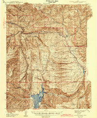
1942 Map of Soldier Summit
USGS Topo · Published 1942About this map
The Colorado River Great Basin Watershed Divide cuts through this high-altitude landscape, defining the hydrology of a region where transport and topography are inextricably linked. The Denver and Rio Grande Western railroad tracks follow the winding path of Soldier Creek, passing through key freight and helper stations like Soldier Summit and Gilluly. This corridor served as a critical mountain pass, connecting the coal-rich regions of Carbon County to the north.
Find a feature on this map
56 named features on this map. Tap any name to fly to it.
Don’t see what you’re looking for? This feature index may not catch every label — zoom into the map to look around manually.
Map Details
Editions of this 1942 Soldier Summit Map
2 editions found
Other maps of this area

1885 · Salt Lake
USGS Topo · 1:250,000

1885 · Manti
USGS Topo · 1:250,000

1885 · Uinta
USGS Topo · 1:250,000

1886 · Price River
USGS Topo · 1:250,000

1895 · Manti
USGS Topo · 1:250,000

1896 · Price River
USGS Topo · 1:250,000

1907 · Strawberry Valley
USGS Topo · 1:125,000

1909 · Strawberry Valley
USGS Topo · 1:125,000

1914 · Castle Gate
USGS Topo · 1:62,500

1916 · Castle Gate
USGS Topo · 1:62,500