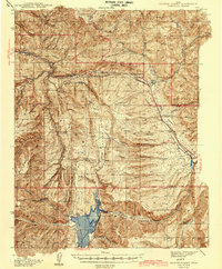
1942 Map of Soldier Summit
USGS Topo · Published 1942About this map
The Great Basin Watershed Divide runs through this high-altitude landscape, separating the headwaters of the Price River and White River from the Colorado River Watershed. At the center of this mountain pass sits Soldier Summit, a critical railway point on the Denver and Rio Grande Western railroad. This 1942 edition reflects the area's essential transportation and industrial importance during the mid-20th century, serving as a vital corridor between the Wasatch Front and the coal-rich basins to the southeast. Settlement is sparse, characterized by working homesteads such as Daniels Ranch, Coddington Ranch, and Richards Ranch, along with the small railroad community at Colton. To the south, the waters of the Scofield Reservoir and operations at the Pondtown Mine highlight the intersection of natural resources and early 20th-century industry in the high country of the Manti National Forest.
Find a feature on this map
53 named features on this map. Tap any name to fly to it.
Don’t see what you’re looking for? This feature index may not catch every label — zoom into the map to look around manually.
Map Details
Editions of this 1942 Soldier Summit Map
2 editions found

Other maps of this area

1885 · Salt Lake
USGS Topo · 1:250,000

1885 · Manti
USGS Topo · 1:250,000

1885 · Uinta
USGS Topo · 1:250,000

1886 · Price River
USGS Topo · 1:250,000

1895 · Manti
USGS Topo · 1:250,000

1896 · Price River
USGS Topo · 1:250,000

1907 · Strawberry Valley
USGS Topo · 1:125,000

1909 · Strawberry Valley
USGS Topo · 1:125,000

1914 · Castle Gate
USGS Topo · 1:62,500

1916 · Castle Gate
USGS Topo · 1:62,500