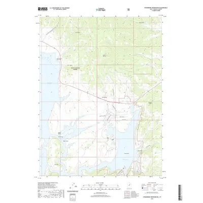
2020 Map of Strawberry Reservoir NE
USGS Topo · Published 2020About this map
The Uinta National Forest dominates this mountain landscape, where the waters of the Strawberry River and its tributaries define the rugged topography of Wasatch County. A major piece of hydraulic infrastructure, the West Portal Water Hollow Tunnel, connects Coal Canyon to the northern reaches of the Strawberry Reservoir, illustrating the complex water management systems of the region. The map reveals a network of high-elevation features like Square Top Mtn and Island Mtn, separated by deep drainages such as Road Hollow and Wildcat Canyon. This modern survey highlights how recreational and service access has expanded through roads like Strawberry Lakeview Dr and Windy Ridge Rd, which skirt the eastern shores and provide access to sites like Soldier Springs and the Strawberry Narrows.
Find a feature on this map
35 named features on this map. Tap any name to fly to it.
Don’t see what you’re looking for? This feature index may not catch every label — zoom into the map to look around manually.
Map Details
Editions of this 2020 Strawberry Reservoir NE Map
This is the sole edition of this map. No revisions or reprints were ever made.
Other maps of this area

1885 · Salt Lake
USGS Topo · 1:250,000

1885 · Uinta
USGS Topo · 1:250,000

1907 · Strawberry Valley
USGS Topo · 1:125,000

1909 · Strawberry Valley
USGS Topo · 1:125,000

1954 · Salt Lake City
USGS Topo · 1:250,000

1958 · Salt Lake City
USGS Topo · 1:250,000

1960 · Salt Lake City
USGS Topo · 1:250,000

1962 · Deep Creek Canyon
USGS Topo · 1:24,000

1962 · Raspberry Knoll
USGS Topo · 1:24,000
1962 · Strawberry Peak
USGS Topo · 1:24,000