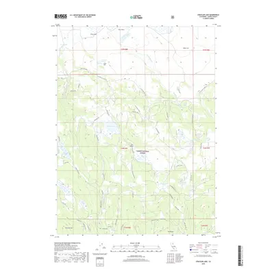
2018 Map of Straylor Lake
USGS Topo · Published 2018About this map
Lassen National Forest terrain in Lassen County defines this high-elevation landscape, where a complex network of forest routes and spurs connects remote water sources and camps. The map reveals a land managed for both conservation and seasonal use, evidenced by locations like Puls Camp and Board Cabin. Water management is central to the area's geography, with numerous small reservoirs such as Catfish Reservoir and Chico Flat Reservoir dotting the plateaus. Notable natural features include the namesake Straylor Lake and the unusually named Hole in the Ground near the southern boundary. The presence of Russell Dairy Cr and Russell Dairy Spring suggests a history of grazing or ranching activities integrated into the forest's rugged interior, while prominent peaks like Patterson Mtn and Harvey Mtn provide significant vertical relief.
Find a feature on this map
46 named features on this map. Tap any name to fly to it.
Don’t see what you’re looking for? This feature index may not catch every label — zoom into the map to look around manually.
Map Details
Editions of this 2018 Straylor Lake Map
This is the sole edition of this map. No revisions or reprints were ever made.
Other maps of this area

1886 · Honey Lake
USGS Topo · 1:250,000

1886 · Lassen Peak
USGS Topo · 1:250,000

1891 · Honey Lake
USGS Topo · 1:250,000

1892 · Lassen Peak
USGS Topo · 1:250,000

1893 · Honey Lake
USGS Topo · 1:250,000

1894 · Lassen Peak
USGS Topo · 1:250,000

1939 · Halls Flat
USGS Topo · 1:125,000

1955 · Westwood
USGS Topo · 1:250,000

1956 · Hayden Hill
USGS Topo · 1:62,500

1956 · Harvey Mtn
USGS Topo · 1:62,500