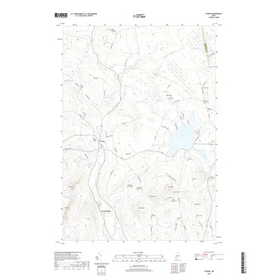
2018 Map of Strong
USGS Topo · Published 2018About this map
Strong and South Strong anchor this Maine landscape, situated where the Sandy River winds through the valley between Hunter Mtn and Dyer Hill. The area is notably dense with small family and village burial grounds, such as the Strong Village Cem, Cunningham Cates Cem, and Peabody Corner Cem, offering significant data for genealogical research. The geography transitions from the fertile Hartwell Intervale to the high elevations of Pratt Mtn and Stubbs Mtn. Large water bodies like Porter Lake and Taylor Hill Pond dominate the eastern half of the map, while numerous brooks, including Valley Brook and McLeary Brook, drain the surrounding ridges. This survey illustrates the persistence of rural settlement patterns, with homesteads clustered along roads like Church Hill Rd and Taylor Hill Rd amidst a landscape of timber and topography.
Find a feature on this map
85 named features on this map. Tap any name to fly to it.
Don’t see what you’re looking for? This feature index may not catch every label — zoom into the map to look around manually.
Map Details
Editions of this 2018 Strong Map
This is the sole edition of this map. No revisions or reprints were ever made.
Other maps of this area

1924 · Farmington
USGS Topo · 1:62,500

1926 · Dixfield
USGS Topo · 1:62,500

1929 · Phillips
USGS Topo · 1:48,000

1929 · Dixfield
USGS Topo · 1:62,500

1930 · Kingfield
USGS Topo · 1:48,000

1932 · Phillips
USGS Topo · 1:62,500

1932 · Kingfield
USGS Topo · 1:62,500

1950 · Lewiston
USGS Topo · 1:250,000

1956 · Dixfield
USGS Topo · 1:48,000

1956 · Farmington
USGS Topo · 1:62,500