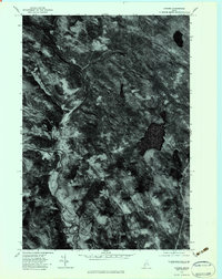
1977 Map of Strong
USGS Topo · Published 1983About this map
Sandy River winds through this 1977 orthophotograph, defining the central valley that historically supported the development of Strong and South Strong. Unlike a traditional topographic sheet, this imagery captures the exact agricultural and timber patterns of the late 1970s, revealing the cleared fields and wooded ridgelines surrounding Gammon Pond. The contrast between the dense forest and the distinct clearings near Bean Brook provides a literal view of the Franklin County landscape as it existed during this period, showing the precise footprints of buildings and roads within the river valley. This aerial perspective is particularly valuable for researchers tracing the physical extent of the timber industry and rural land use in the Western Maine mountains.
Find a feature on this map
5 named features on this map. Tap any name to fly to it.
Don’t see what you’re looking for? This feature index may not catch every label — zoom into the map to look around manually.
Map Details
Editions of this 1977 Strong Map
This is the sole edition of this map. No revisions or reprints were ever made.
Other maps of this area

1924 · Farmington
USGS Topo · 1:62,500

1926 · Dixfield
USGS Topo · 1:62,500

1929 · Phillips
USGS Topo · 1:48,000

1929 · Dixfield
USGS Topo · 1:62,500

1930 · Kingfield
USGS Topo · 1:48,000

1932 · Phillips
USGS Topo · 1:62,500

1932 · Kingfield
USGS Topo · 1:62,500

1950 · Lewiston
USGS Topo · 1:250,000

1956 · Dixfield
USGS Topo · 1:48,000

1956 · Farmington
USGS Topo · 1:62,500