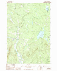
1989 Map of Strong
USGS Topo · Published 1989About this map
Strong serves as the primary settlement center on this map, positioned at the confluence of the Sandy River and Valley Brook. The landscape is defined by its numerous water bodies and significant topographical relief, ranging from the low-lying Hartwell Intervale to peaks like Allen Pinnacle, Hartwell Mtn, and Stubbs Mtn. The eastern portion of the quadrangle is dominated by Porter Lake, which features a Boat Ramp for access, and is flanked by the small village of New Vineyard.
Find a feature on this map
44 named features on this map. Tap any name to fly to it.
Don’t see what you’re looking for? This feature index may not catch every label — zoom into the map to look around manually.
Map Details
Editions of this 1989 Strong Map
This is the sole edition of this map. No revisions or reprints were ever made.
Other maps of this area

1924 · Farmington
USGS Topo · 1:62,500

1926 · Dixfield
USGS Topo · 1:62,500

1929 · Phillips
USGS Topo · 1:48,000

1929 · Dixfield
USGS Topo · 1:62,500

1930 · Kingfield
USGS Topo · 1:48,000

1932 · Phillips
USGS Topo · 1:62,500

1932 · Kingfield
USGS Topo · 1:62,500

1950 · Lewiston
USGS Topo · 1:250,000

1956 · Dixfield
USGS Topo · 1:48,000

1956 · Farmington
USGS Topo · 1:62,500